This project developed out of ART330/HLS331: Venice and the Mediterranean, taught by Professor Patricia Fortini Brown in Spring 2007. The course explored the artistic and cultural geography of Venice's Mediterranean empire, known as the stato da mar, from its beginnings in 1204 to the loss of Crete in 1669. The focus was primarily on "Venetian Crete" as it underwent a series of transformations from Byzantine to Venetian to Ottoman rule.
During a 9-day trip to Crete, sponsored by the Program in Hellenic Studies,
students discovered a unique cultural palimpsest, with layers of physical remains
from the Minoan, Roman, Byzantine, Venetian, and Ottoman periods still visible in
the cities and the countryside. The class then collaborated on the construction of
the website, using photographs made on the trip and providing commentaries for a
defined group of monuments.
For further reading, click here (49KB PDF).![]() Explore Cities and Sites
Explore Cities and Sites
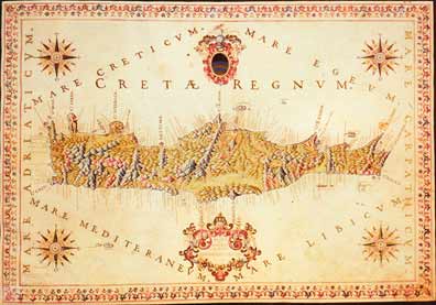
Right: Francesco Basilicata’s Cretae Regnum, a manuscript made in 1518-19, consisted of 43 maps, plans and views of its landscape, cities, fortresses and castles.